

Coastal Skipper and Yachtmaster Quiz
Tidal calculations, position fixing, passage planning, radar, collision regulations, meteorology and heavy weather.
Coastal Skipper and Yachtmaster Test
Or practise one topic:
Every Question in This Test
Tidal calculations (6)
-
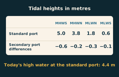 Using this table, what is the height of today's high water at the secondary port?
 -
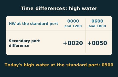 Using this table, at what time is today's high water at the secondary port?
 -
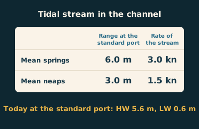 Using this table and today's tide at the standard port, what rate should you expect from the stream?
 -
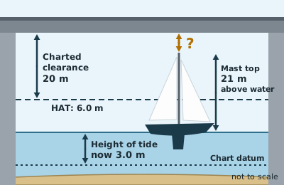 The chart gives the clearance under this bridge as 20 m, measured above HAT, and HAT here is 6.0 m above chart datum. With the figures shown, how much room is there above the masthead?
 -
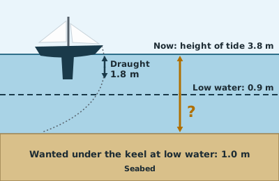 You are choosing where to anchor for the night. With these figures, what is the least depth of water you should anchor in now?
 -
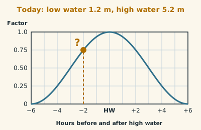 Read the factor from this tidal curve at the gold marker, 2 hours before high water. What is the height of tide at that time?
Position fixing (6)
-
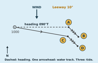 She steered 090°T for an hour with a northerly wind giving 10° of leeway. Which point is her estimated position?
 -
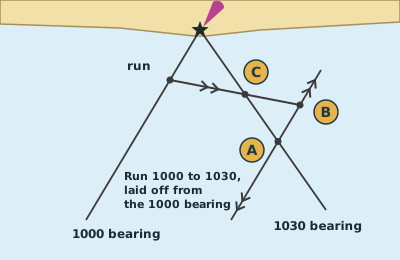 Only one lighthouse is in sight, so the navigator takes two bearings of it half an hour apart and plots this running fix. Where is the yacht at 1030?
 -
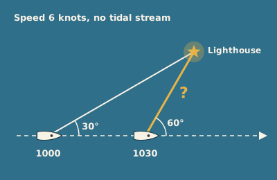 The angle on the bow to the lighthouse has doubled, from 30° at 1000 to 60° at 1030. How far is the yacht from the lighthouse at 1030?
 -
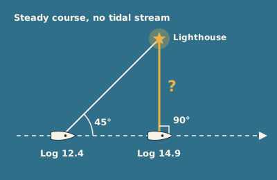 The lighthouse was 45° on the bow when the log read 12.4, and it is abeam now, with the log reading 14.9. How far off is it now?
 -
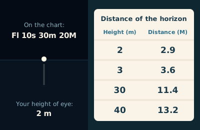 On a clear night this light is just dipping on the horizon. Using the table, how far away is it?
 -
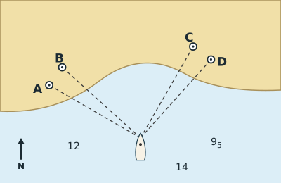 You have time for only two bearings. Which pair of landmarks gives the most reliable fix?
Chartwork and passage planning (7)
-
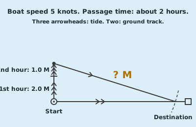 This course to steer covers a two-hour passage, with both hours of tide laid off from the start. How long is the line marked with a question mark, struck from the end of the tide to the ground track?
 -
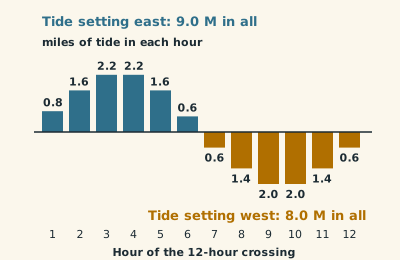 On a 12-hour crossing the tide sets you east for six hours, then west for six. To work out one course to steer for the whole crossing, what tidal set do you allow for?
 -
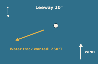 You want a water track of 250°T. The wind is from the south and you expect 10° of leeway. What course do you steer?
 -
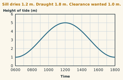 A marina sill dries 1.2 m. You draw 1.8 m and want 1.0 m under the keel. Reading this curve, between what times can you cross the sill?
 -
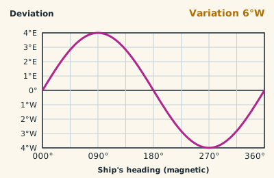 The course drawn on the chart is 084°T. Using the variation shown and this deviation curve, what course do you steer by the ship's compass?
 -
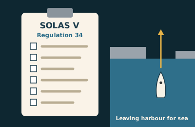 SOLAS V regulation 34 applies to every vessel that goes to sea, small yachts included. What does it require of the skipper?
 -
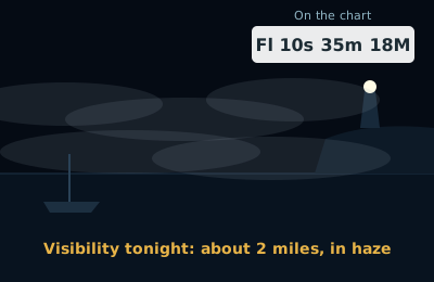 You are making a night landfall on this light, charted with a range of 18M. Tonight the visibility is about 2 miles. At what distance should you expect to pick it up?
Electronic navigation (7)
-
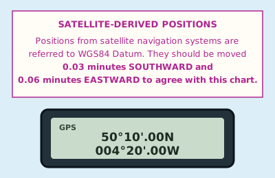 Your GPS is working in WGS84 and the chart carries this note. What position do you plot?
 -
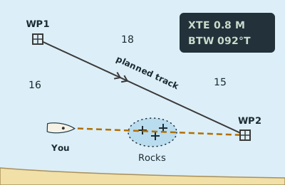 The tide has set you well off your planned track, and the GPS now offers a new bearing straight to the waypoint (the dashed line). What is wrong with simply following it?
 -
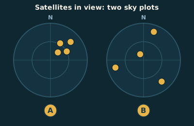 Which of these satellite patterns gives the more accurate position, and how does the receiver show it?
 -
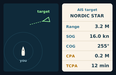 What do the CPA and TCPA figures for this AIS target tell you?
 -
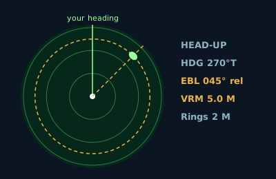 The radar is in head-up mode and you are steering 270°T. The electronic bearing line (EBL) through the target reads 045° relative. What is the true bearing of the target?
 -
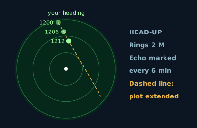 You have marked this target three times and extended the line through the marks. If neither of you alters, about how close will she pass?
 -
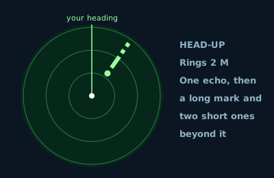 The echo of a buoy on your radar has a trail beyond it: one long mark and two short ones, pointing away from you. What is it?
Collision regulations (6)
-
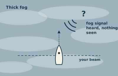 In thick fog you hear another vessel's fog signal, apparently forward of your beam. You cannot tell whether there is a risk of collision. What does Rule 19 require?
 -
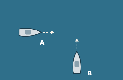 These two motor boats are in clear visibility and risk of collision exists. B is the stand-on vessel, but A is doing nothing. When is B first allowed to manoeuvre?
 -
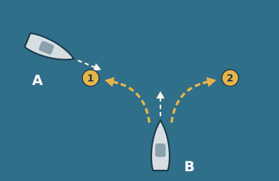 B is the stand-on motor boat and A is not keeping clear. B decides to take action early, as Rule 17 allows. Which manoeuvre should she avoid, if the circumstances of the case admit?
 -
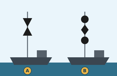 Vessel A is trawling and vessel B is laying a cable. Both are underway in open water, in sight of each other, neither is overtaking, and risk of collision exists. Which keeps out of the way?
 -
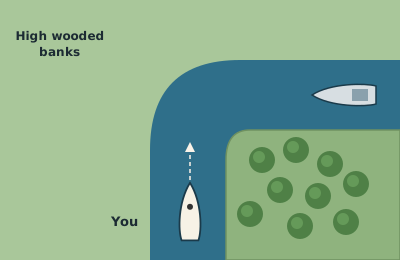 You are nearing a bend in a channel where the bank hides anything coming the other way. What sound signal does Rule 34 require?
 -
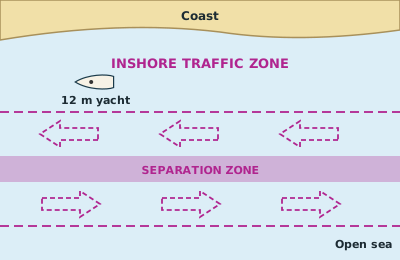 You are on passage along this coast in a 12 m yacht. May you use the inshore traffic zone, or must you join the traffic lane?
Meteorology (7)
-
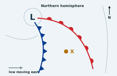 You are at X, between the two fronts of this depression. What weather is typical there?
 -
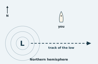 This depression is going to pass to the south of you. What will the wind do as it goes by?
 -
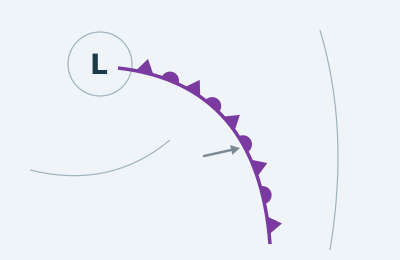 This front carries triangles and semicircles together. How does a front like this form?
 -
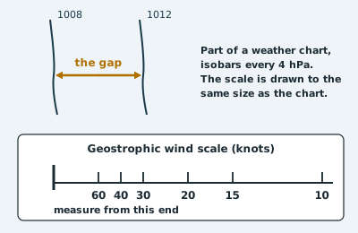 Measure the gap between the two isobars and lay it on the geostrophic wind scale from its left-hand end. What wind speed does it give?
 -
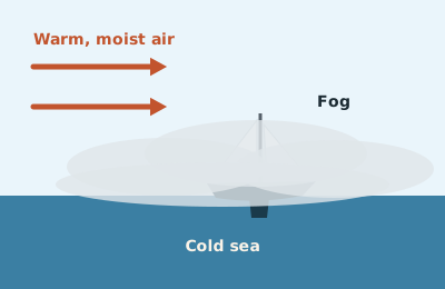 Fog has formed as shown, where warm, moist air is blowing over a colder sea. What type of fog is it, and will a fresh breeze clear it?
 -
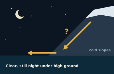 On a clear, still night, air flows down these slopes and out over the water, as shown by the arrows. What is this wind called?
 -
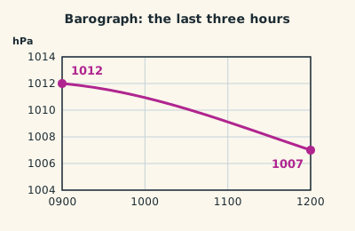 How would a Met Office marine forecast describe the pressure change shown on this barograph over the last three hours?
Heavy weather and stability (6)
-
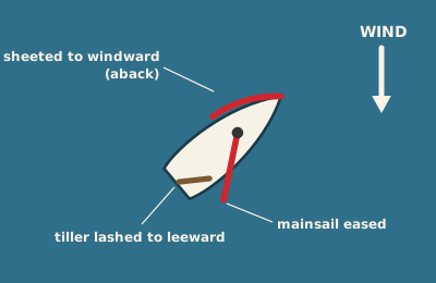 This yacht has her jib sheeted to windward, her mainsail eased and her tiller lashed to leeward. What is she doing?
 -
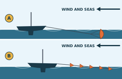 Which of these is a drogue, and what is it for?
 -
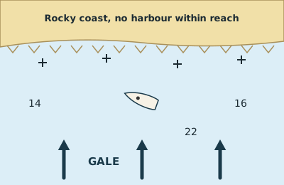 A gale is forecast to blow straight on to this coast, and there is no harbour you can reach before it arrives. What is the seamanlike choice?
 -
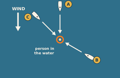 You are returning under sail to a person in the water. Which approach lets you control your speed and stop alongside?
 -
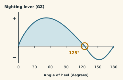 This is a stability (GZ) curve for a yacht. What does the ringed point at 125° tell you?
 -
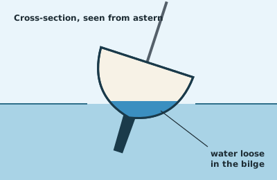 A lot of water has got below and is sloshing about in the bilge. What does that do to the yacht's stability?
Safety and communications (5)
-
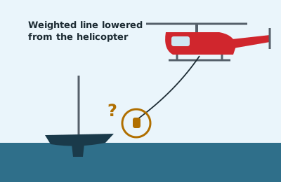 A rescue helicopter is using a hi-line and lowers a weighted line to your yacht first. What do you do with it?
 -
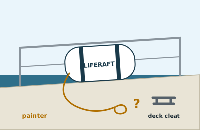 You are about to launch the liferaft. What must you check about its painter before the canister goes over the side?
 -
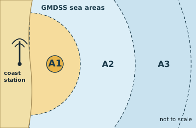 GMDSS divides the sea into areas A1 to A4. What defines sea area A1, the band nearest the coast station?
 -
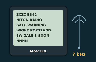 On what frequency does the international NAVTEX service broadcast, in English, to a set like this?
 -
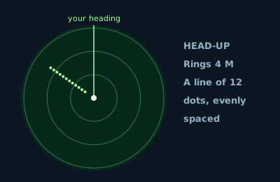 A straight line of 12 evenly spaced dots has appeared on your radar. What is it, and where is the thing that is making it?
How These Questions Are Checked
SailChecker writes every question and checks each answer against the published source for its subject before it goes live. Where a rule says "so far as practicable", the answer says so too. Chart symbols follow UKHO Chart 5011.
- International Regulations for Preventing Collisions at Sea (COLREGs), IMO: lights, shapes, sound signals and the steering rules.
- IALA Maritime Buoyage System: buoys, topmarks and light rhythms.
- RYA Competent Crew course: what the Competent Crew test covers.
- RYA Day Skipper theory course: what the Day Skipper test covers.
- Met Office marine forecast glossary: forecast terms, visibility and the Beaufort scale.
- MCA GMDSS procedures for small boat users: distress calls and DSC.
These are independent practice questions that follow the RYA syllabuses. They are not official RYA papers, and a score here is not a qualification.
Last checked: October 2026. Spotted a mistake? Tell us at enquire@sailchecker.com.
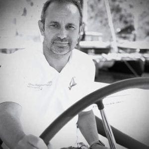
Christopher Lait
Chris founded Drake Academy, a sailing company that provides leadership training to businesses. Now the CEO of SailChecker.com you will find him handling many of your enquiries as he attempts to drive SailChecker.com forward as the company of choice for yacht charter and sailing by focusing on quality advice and great customer service.