Coastal Skipper and Yachtmaster Quiz · Electronic navigation
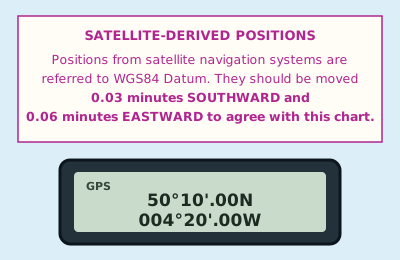
Your GPS is working in WGS84 and the chart carries this note. What position do you plot?
A note printed on a chart, headed satellite-derived positions. It reads: positions from satellite navigation systems are referred to WGS84 Datum. They should be moved 0.03 minutes southward and 0.06 minutes eastward to agree with this chart. Below it, a GPS display reads 50°10'.00N 004°20'.00W.
Show the answer
50°09'.97N 004°19'.94W. A chart drawn on a different datum from the GPS needs the shift printed in its note. Moving south makes a north latitude smaller, and moving east makes a west longitude smaller. The other way to do it is to set the GPS to the datum of the chart, but never do both.