Coastal Skipper and Yachtmaster Quiz · Electronic navigation
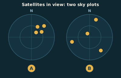
Which of these satellite patterns gives the more accurate position, and how does the receiver show it?
Two circular sky plots, each showing four satellites as gold dots, with north at the top and the horizon as the outer ring. In plot A the four satellites are bunched close together in the north-east part of the sky. In plot B they are spread widely: one almost overhead and three low down, spaced round the horizon.
Show the answer
B: satellites spread widely, shown by a low HDOP figure. A GPS fix is like a fix from bearings: it is best when the position lines cross at wide angles. Satellites spread across the sky give a good cut and a low HDOP (horizontal dilution of precision), which means good geometry, other errors being equal. Satellites bunched together give a poor cut and a high HDOP, so treat the position with more caution.