

Round Trips from Kos and the north Dodecanese
Here is where tracked sailing boats went on round trips from the bases in Kos and the north Dodecanese during the complete 2025 season. This is a record of past trips, not a guide to future trips.
Observed Positions
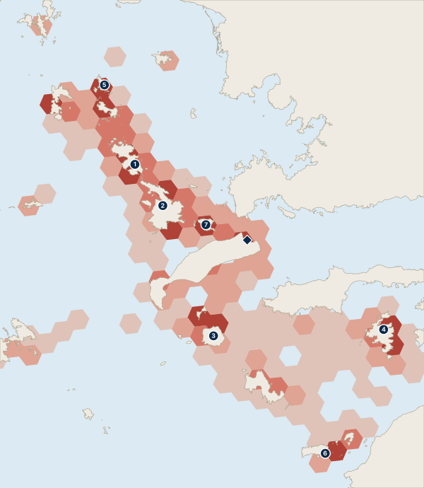
Top Overnight Stops
- Leros 55%
- Kalymnos 47%
- Nisyros 28%
- Symi 27%
- Arki 24%
- Chalki 22%
- Pserimos 18%
The percentage is the share of trips that spent at least one night there.
Week Shapes
Each shape names the three places where a trip spent the most nights, so other stops may be left out. The percentage is the share of round trips from this area with at least four known nights away from base that had that shape.
- 1. Kalymnos, Leros, Lipsi 14% of these trips
- 2. Kalymnos, Patmos, Leros 8% of these trips
First Nights
| Kalymnos | 29% |
| Nisyros | 14% |
| Gyali | 11% |
| Elsewhere | 45% |
Last Nights
| Kalymnos | 28% |
| Nisyros | 15% |
| Leros | 13% |
| Elsewhere | 43% |
Shares are of trips whose first or last night was recorded, respectively.
Furthest From Base
- under 40 nm 40%
- 40 to 60 nm 55%
- over 60 nm 5%
The furthest point reached on each trip, measured in a straight line from base in nautical miles. This is not the distance sailed.
Following Nights
For each favourite stop, this shows where boats spent the following night, as a share of those following nights.
| Lipsi | 24% |
| Kalymnos | 15% |
| Pserimos | 7% |
| Stayed Another Night | 22% |
| Back to Base | 15% |
| Other Places | 17% |
| Leros | 28% |
| Stayed Another Night | 15% |
| Back to Base | 36% |
| Other Places | 21% |
| Symi | 19% |
| Stayed Another Night | 13% |
| Back to Base | 32% |
| Other Places | 35% |
Find boats based in Kos and the north Dodecanese
How We Worked This Out
We used AIS positions bought from Datalastic for the 2025 season, covering sailing yachts and catamarans based in the area. A trip is the nights away between two nights at base, so only round trips are included. A place is shown only when enough different boats went there, and no single boat can be picked out. Place names and coastline come from OpenStreetMap contributors.
Aggregated AIS ship-tracking data for the sailing area. No individual boat is shown, and these patterns do not predict future routes.
© OpenStreetMap contributors